Log in
Enquire now
Vexcel Data Program

Vexcel Data Program

Vexcel Data Program is the world's largest aerial imagery and geospatial data provider and a subsidiary of Vexcel Imaging.

OverviewStructured DataIssuesContributors

Contents

OverviewProductsTimelineTable: PatentsTable: Further ResourcesReferences
vexceldata.com
Is a
Organization
Organization

Organization attributes

Location
Graz
Graz
10
Austria
Austria
10
Centennial, Colorado
10
Industry
Geospatial intelligence
8
Geospatial analysis
Geospatial analysis
8
Parent Organization
Vexcel Imaging
Vexcel Imaging

Other attributes

Blog
vexceldata.com/blog/
Company Operating Status
Active8
Competitors
Maxar Technologies
Maxar Technologies
9
EagleView Technologies
9
Nearmap
Nearmap
9
Email Address
info@vexcel-imaging.com10
Full Address
12503 E Euclid Dr, Centennial, Colorado 801112
Headquarters
Centennial, Colorado
2
Partner Organizations
Intel Geospatial
Intel Geospatial
11
Esri
Esri
11
Munich Re
Munich Re
11
Verisk
Verisk
11
CoreLogic
CoreLogic
11
BetterView
BetterView
11
Athenium
Athenium
11
Geospan
Geospan
11
...
Phone Number
+43316849066010
Public/Private
Private1
Overview

The Vexcel Data Program (VDP) is an imagery-as-a-service company that provides aerial imagery and geospatial data, which gives its customers access to its library of content via a cloud-based platform. VDP has captured programs in over twenty-five countries, including the United States, United Kingdom, Canada, Western Europe, New Zealand, Puerto Rico, Japan, and Australia, and collects both urban and rural location imagery.

The industries VDP serves include the following:

  • government
  • insurance
  • energy
  • utilities
  • telecommunications
  • AEC (architecture, engineering, and construction)

VDP was launched in 2017 by Vexcel Imaging. VDP combines Vexcel Imaging’s expertise in aerial camera systems, mobile mapping platforms, and photogrammetry software together to offer its aerial data products. Customers integrate the geospatial data into their third-party GIS/CAD platforms through APIs and web map tile services (WMTS).

Vexcel Data Program

Products

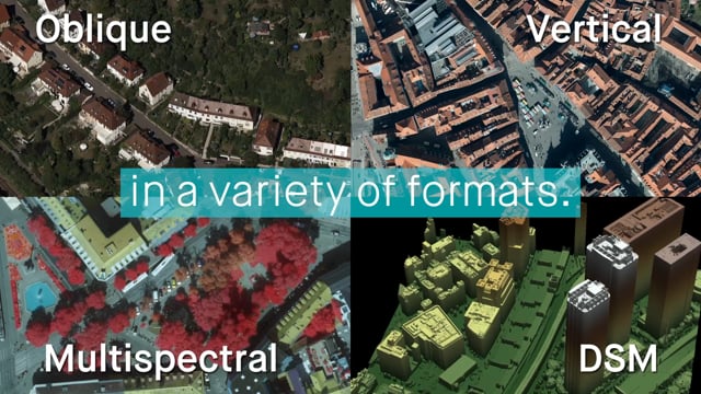
The products VDP offers include Oblique, True Ortho, Ortho, Disaster Imagery, Elevate, Elements, and Multispectral.

VDP's Oblique product provides a complete view of sites with images from all four cardinal directions (north, south, east, and west), collected at a 45-degree angle in ultra-high resolution at 2.9” (7.5cm) or better. True Ortho provides aerial imagery with a resolution of 2.9″ (7.5 cm) or better without building lean, allowing for customers to easily distinguish between objects on the ground and take accurate measurements of an area. Ortho also provides aerial imagery that is four times more clear than satellite images and wider than drone images, but not as high resolution as the True Ortho images.

VDP's Disaster Imagery product provides the most comprehensive post-catastrophe imagery library in the industry offering rapid access to high-resolution aerial imagery and data specifically for natural disaster response.

Vexcel Data Program Disaster Imagery Product

Vexcel Data Program Disaster Imagery Product

VDP's Multispectral product uses color-infrared (CIR) imagery to help classify vegetation, identify impervious surfaces, and more. The Elevate product uses digital surface model (DSM) data to provide a clear view of the ground’s surface and man-made objects, allowing customers to import the DSM/DTM data or to power automatic feature extraction and machine learning applications. Finally, the Elements product allows customers to view more than twenty property and building attributes in aerial images.

Timeline

No Timeline data yet.

Patents

Further Resources

Title
Author
Link
Type
Date

Vexcel Announces Image Services for ArcGIS

https://www.yahoo.com/now/vexcel-announces-image-services-arcgis-160000633.html

Web

February 6, 2022

Vexcel Data Program Enhances Wide Area Capture Program in U.S. and Europe

Vexcel Data Program

https://www.prnewswire.com/news-releases/vexcel-data-program-enhances-wide-area-capture-program-in-us-and-europe-301383107.html

Web

September 22, 2021

Vexcel Data Program Expands Aerial Imagery Collection Program To Japan

Vexcel Data Program

https://www.prnewswire.com/news-releases/vexcel-data-program-expands-aerial-imagery-collection-program-to-japan-301392854.html

Web

October 5, 2021

References

Find more entities like Vexcel Data Program

Use the Golden Query Tool to find similar entities by any field in the Knowledge Graph, including industry, location, and more.
Open Query Tool
Access by API
Golden Query Tool
Golden logo

Company

  • Home
  • Press & Media
  • Blog
  • Careers
  • WE'RE HIRING

Products

  • Knowledge Graph
  • Query Tool
  • Data Requests
  • Knowledge Storage
  • API
  • Pricing
  • Enterprise
  • ChatGPT Plugin

Legal

  • Terms of Service
  • Enterprise Terms of Service
  • Privacy Policy

Help

  • Help center
  • API Documentation
  • Contact Us
By using this site, you agree to our Terms of Service.