

One of the largest forest areas on the continent, Polissya is located in the southwestern part of the Eastern-European Lowland, the Polissyan Lowland. On the western side, Polissya originates at the crossing of the Bug River valley in Poland and the Pripyat River valley of Western Ukraine. The swampy areas of central Polissyaare known as the Pinsk Marshes (after the major local city of Pinsk). Large parts of the region were contaminated after the Chernobyl disaster and the region now includes the Chernobyl Exclusion Zone and Polissya State Radioecological Reserve, named after the region.
The names Polesia/Polissia/Polesye, etc. may reflect the Slavic root les, which means "forest", and the Slavic prefix po-, which means "on", "in" or "along". Inhabitants of Polissya are called Polishchuks.
The term is not related to "Poland", "Polish," "Pole", etc., which is derived ultimately from Old Slavic pole, "field."
In ancient times, the areas of today's western and west-central Polissya were inhabited by the people of the Milograd culture, the Neuri.
In the late Middle Ages Polissya became part of the Grand Duchy of Lithuania, following it into the Polish–Lithuanian Commonwealth (1569). Polissya was largely part of Poland from 1921 to 1939, when the country's largest provinces bore that name. Polissya has rarely been a separate administrative unit. However, there was a Polissya Voivodeship during the Second Polish Republic, as well as a Polissya Voblast in Byelorussian SSR. From 1931 to 1944, it was explicitly mentioned as constituent part of the short-lived (Byzantine Rite) Ukrainian Catholic Apostolic Exarchate of Volhynia, Polissya and Pidliashia. Since the end of World War II, the region of Polissya has encompassed areas in eastern Poland, southern Belarus, northwestern Ukraine, and southwestern Russia.
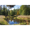
Polissya is a marshy region lining the Pripyat River (Pripyat Marshes) in Southern Belarus (Brest, Pinsk, Kalinkavichy, Gomel), Northern Ukraine (in the Volyn, Rivne, Zhytomyr, Kyiv and Chernihiv Oblasts), and partly in Poland (Lublin) and Russia (Bryansk). It is a flatland within the drainage basins of the Western Bug and Prypyat rivers. The two rivers are connected by the Dnieper-Bug Canal, built during the reign of Stanislaus II of Poland, the last king of the Polish–Lithuanian Commonwealth.
Notable tributaries of the Pripyat are the Horyn, Stokhid, Styr, Ptsich, and Yaselda rivers. The largest towns in the Pripyat basin are Pinsk, Stolin, Davyd-Haradok. Huge marshes were reclaimed from the 1960s to the 1980s for farmland. The reclamation is believed to have harmed the environment along the course of the Pripyat.
This region suffered severely from the Chernobyl disaster. Huge areas were polluted by radioactive elements. The most polluted part includes the Chernobyl Exclusion Zone and the adjacent Polissya State Radioecological Reserve. Some other areas in the region are considered unsuitable for living as well.
The Polish part of the region includes the Polissya National Park (Poleski Park Narodowy), established 1990, which covers an area of 97.6 square kilometres (37.7 sq mi). This and a wider area adjoining it (up to the Ukrainian border) make up the UNESCO-designated West Polissya Biosphere Reserve, which borders a similar reserve (the Shatskiy Biosphere Reserve) on the Ukrainian side. There is also a protected area called Pribuzhskoye-Polesie in the Belarusian part of the region.
The wooden architecture structures in the region were added to the UNESCO World Heritage Tentative List on 30 January 2004 in the Cultural category.


