Other attributes


Intense Tropical Cyclone Batsirai was the strongest tropical cyclone to strike Madagascar since Enawo in 2017 and the strongest tropical cyclone worldwide in 2022 thus far, and the second of tropical cyclones to impact Madagascar within two weeks in the 2021–22 South-West Indian Ocean cyclone season. The second tropical disturbance, first tropical cyclone and first intense tropical cyclone of the season, Batsirai was first noted as a tropical disturbance on 24 January. It fluctuated in intensity and became a moderate tropical storm on 27 January, after which it unexpectedly intensified into an intense tropical cyclone. It then weakened, and struggled to intensify through the coming days due to present wind shear and dry air, where it weakened after some time. Afterwards, it entered into much more favorable conditions, and it rapidly intensified into a high-end Category 4 cyclone on the Saffir–Simpson scale while moving towards Madagascar. The storm subsequently underwent an eyewall replacement cycle for the next day, and fluctuated in intensity before making landfall in Madagascar as a Category 3 cyclone, and rapidly weakening due to the immense mountainous terrain thereafter.
Mauritius and Réunion both experienced damage from the storm, though effects were relatively minor. Two people were killed in Mauritius. Madagascar prepared recovery supplies as the storm approached, with worries of significant flooding rising due to the deforested geography of the country. Millions were expected to be affected. The United Nations supported preparation and relief efforts for after the storm as well. The storm made landfall in the country early on 5 February, bringing heavy effects and majorly disrupting power and communication throughout the affected areas. Nearly entire towns were devastated, with thousands of structured being damaged or destroyed in total. After the storm passed, tens of thousands of people were displaced in Madagascar, with many being evacuated to temporary shelters. 21 deaths have been reported in the country.
The origins of Cyclone Batsirai were from an area of convection which was designated as Invest 96S over the eastern part of the basin, located approximately 493 nmi (913 km; 567 mi) from the Cocos Islands 5 hours later, along with its disorganized convection over a broad LLC the system was also located within a marginally favourable environment for further development, with high levels of vertical wind shear, being offset by warm sea surface temperatures of around 29–30 °C (84–86 °F) The JTWC[nb 1] gave a low chance for potential cyclogenesis within the next 24 hours. A day later at 00:30 UTC, the agency upgraded the probability to medium after the system gradually improved its convective pattern. Later at 21:30 UTC the same day, the agency issued a Tropical Cyclone Formation Alert (TCFA) for Invest 96S, after noting its obscure low-level circulation center. Meanwhile, at midday of 25 January, the MFR[nb 2] recognized the same low pressure system and later upgraded it to a tropical disturbance status at 06:00 UTC the next day. According to them, the system's convection had shown signs of gradual organization since 24 January. The center had became better defined with low-level clouds converging towards it in a defined circular pattern, suggesting that a closed circulation had formed. The MFR further upgraded it to a tropical depression at 12:00 UTC the same day, as it continued to improve its convective structure along its low-level center. After its convective activity was briefly interrupted after 18:00 UTC due to dry air. The JTWC subsequently initiated advisories on the system and classified it as Tropical Cyclone 08S at 03:00 UTC the next day.
Three hours later, the MFR upgraded it to a moderate tropical storm and named it Batsirai. Between 06:00 UTC and 12:00 UTC, Batsirai underwent a rapid deepening and intensified from a moderate tropical storm to an intense tropical cyclone within a span of just three hours. According to the MFR, it was favoured by the very small size of the system and its fast movement. It had also established an inner core of 75 to 90 km (45 to 55 mi) in diameter. Two hours later, the JTWC also upgraded it to a Category 2 tropical cyclone on the Saffir–Simpson scale, as it developed a small eye at about 7 nmi (13 km; 8.1 mi) in diameter. However, by 18:00 UTC, it started to rapidly decline after its eye quickly collapsed and the cloud tops had warmed since. Because of these reasons, the MFR downgraded to a tropical cyclone. At midnight of 28 January, it further downgraded to a moderate tropical storm, after further weakening of the convective structure. Three hours later, the JTWC downgraded back to a tropical storm status.
Batsirai resumed its intensification after upgrading to a severe tropical storm status at 06:00 UTC the next day. Nine hours later, the JTWC upgraded to a Category 1 tropical cyclone. At 03:00 UTC of 30 January, the JTWC further upgraded to a Category 2 tropical cyclone after noting a well-defined central dense overcast (CDO) and a microwave eye feature. The MFR further upgraded it to a tropical cyclone status at midday. Three hours later, the JTWC upgraded to a Category 3 tropical cyclone, as its eyewall had expanded and also developed a 5 nmi (9.3 km; 5.8 mi) wide pinhole-eye. However it was short lived and it re-declined to a Category 1 status by 03:00 UTC of 1 February, as its pinhole-shaped eye just collapsed shortly and its eyewall became disorganized. Possibly because of its struggle to maintain its convective structure against the ever increasing vertical wind shear (VWS), despite high sea-surface temperature (SST). But at 15:00 UTC the same day, it did a comeback to a Category 2 status, as it managed to consolidate and its eye feature re-appeared in the satellite imagery. Three hours later, the MFR upgraded it to a intense tropical cyclone status.
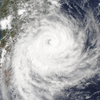
By 03:00 UTC on 2 February, the cyclone underwent another round of rapid intensification, intensifying from a Category 2 to a Category 4 tropical cyclone. Its eyewall rapidly organized and also developed a 15 nmi (28 km; 17 mi) wide eye. After reaching its peak at 12:00 UTC, the eyewall replacement cycle, at 15:00 UTC as satellite imagery depicted formation of another eyewall and also showing signs of weakening. It weakened to a Category 3 system during this time. After completing the eyewall replacement cycle, the storm again briefly became into a Category 4 system with MFR determined that Batsirai central barometric pressure had rapidly fallen to 934 hPa (mbar; 27.58 inHg). It weekened again to Category 3 system as the cyclone has maintained and its overall convective structure.
Gradually weakening due to the land interaction with Madagascar, it made landfall on 17:30 UTC of 5 February close to the city of Nosy Varika. the MFR declared that Batsirai had degenerated into an overland depression and the JTWC downgraded to tropical storm the system entered into the Mozambique channel and the MFR re-upgraded to moderate tropical storm status. By 06:00 UTC on 7 February is weak into an remnant low and weak again into post tropical depression. Despite convective activity high wind shear and lower sea surface temperatures, due to baroclinic forces, the MFR re-upgraded again to moderate tropical storm Then it underwent subtropical transition and the JTWC ceased advisories on the system on 15:00 UTC of 8 February while MFR doing the same six hours earlier as weakened into the post tropical depression it dissipating late on 11 February.
The impacts of Tropical Storm Ana were compounded by the damage that Batsirai brought.
Schools and churches prepared to shelter those displaced around Mananjary. World Food Programme distributed hot meals to 4,000 evacuated and displaced people in shelters. Drinking water and basic necessities were lacking in impacted areas, and the spreading of several diseases was also a concern. A humanitarian crisis was also feared to rise out of the storms effects. Aerial rescue effort first took place on 6 February via an UNHAS flight. The Malagasy government provided households affected with monetary donations. UNICEF also supported relief efforts by giving out kits to create child-friendly spaces in several regions of the country. Other measures were taken to help decrease incidents inside of shelters as well. A team that initially consisted of five EU Civil Protection officials from France, Finland, and Sweden traveled to affected areas to help victims of the storm.
The PRIOI had deployed 87 tons of humanitarian material from its warehouses in the country to use for relief efforts, an effort that cost approximately €667,000.[85] An estimated 75,000 people—including 37,500 children—were in need of relief assistance after Batsirai. WASH partners delivered items to Vatovavy, Fitovinany, and Atsimo Atisinanana regions.


