Other attributes
Sikhote-Alin, a mountain system in the Far East, in Russia: in the Khabarovsk and Primorsky Territories. stretched submeridionally along the coast of the Sea of Japan for 1200 km; width up to 250 km.
Relief
Sikhote-Alin is an asymmetric mountain system with a steeper eastern slope. The relative single-heightness of the top surfaces is characteristic. The highest altitudes are confined to large granite batholiths. The elevations are up to 2090 m (Mount Tardoki-Yangi is the highest point of Sikhote-Alin). The valleys are wide, relatively straight. The relief is mainly denudational and erosive, with smoothed forms. In the northern part of Sikhote-Alin, the relief of structural basalt plateaus, abruptly sloping towards the sea, prevails, some basalt plateaus are also found in the southern part. Low mountains (300-800 m high) are characterized by straight, less often convex slopes, covered with a rather thick layer of rubbly loam; outcrops of bedrock are rare. The central part consists of mid-mountain steep-sloping ridges. Above 700-1100 m, flattened watersheds, rounded peaks and terraced slopes are typical (the most extensive areas are on the watersheds of the Bikin and Bolshaya Ussurka rivers, in the upper reaches of the Ussuri River and along the watersheds of the rivers of the eastern macro-slope). Cryogenic landforms (medallions, kurums, stone rivers, solifluctional forms) are found in the northern part above 1600 m. The glacier relief is very poorly developed, except for some high-altitude areas with rims (at 1700-2000 m) and moraines in the northern part valleys. In the west, narrow tectonic depressions separate the advanced Siniy, East Siniy, Kholodny and other ridges. The shoreline of the Tatar Strait and the Sea of Japan (except for the shores of Peter the Great Bay) is poorly cut, but complicated by ingressive bays (Sovetskaya Gavan, Vladimir, Olga, etc.). On the periphery, facing the Ussuri-Khanka Plain, the shallow-flank terrain predominates.
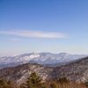
Sikhote-Alin.
Photo by N.V. Pozhidaeva
Tectonically, Sikhote-Alin is a fold-cover system of Late Mesozoic age. From southeast to northwest extends the Central Sikhote-Alin Fault (shear zone), west of which are developed tectonic wedges and sheets (see Tectonic Cover) of volcanogenic, terrigenous, siliceous, carbonate rocks and ophiolites of the Devonian, Carboniferous, Permian, Triassic and Jurassic; widely distributed olistostromes and melange, which include older formations. The accretionary complex is overlain in places by Lower Cretaceous flysch and is broken through by Early Cretaceous and Middle Cretaceous granites. Eastward of the shear zone Sikhote-Alin is composed of the folded and faulted terrigenous and carbonate strata of the Triassic, Jurassic, and Lower Cretaceous, with gently deposited andesites, dacites, rhyolites, Upper Cretaceous-Paleogene tuffs and closely connected with them granitoids intrusions of the marginal volcaniclutonic belt. The Cretaceous-Paleogene volcanites also form development fields west of the Central fault. Small depressions (Uglegorskaya and others) contain coals. In the northern and southern parts of the mountain system are distributed covers of Neogene basalts. There are some sources of deep focus earthquakes at the southern end of the Kurilo-Kamchatka seismic focal zone.
Large deposits of boron (the only deposit in Russia, the Dalnegogorskoe deposit), tin (deposits Tigrinoye, Verkhneye - Primorsky Krai) and tungsten (deposits Skrytoye, Zabytoye - Primorsky Krai) are found in the depths of Sikhote-Alin. Known deposits of lead and zinc (Nikolaevskoe and other deposits of the Dalnegorsk ore district - Primorsky Territory), gold (the Malmyzhskoe gold-copper porphyry deposit - Khabarovsk Territory; Krinichnoe - Primorsky Territory), titanium (the Ariadnenskaya ilmenite placer), and copper, silver, iron; coal (Pavlovskoe deposit - Primorsky Territory), industrial materials, precious and semi-precious stones and natural building materials.
Climate
The climate is temperate monsoonal, with considerable differences in the western and eastern macro-slopes. Dry northwestern and western winds prevail in winter, and humid southeastern and southern winds in summer. Annual temperature ranges decrease towards the coast of the Sea of Japan. Average annual temperatures are 1-5°C. Winter is harsh, with few clouds and little snow. Average temperatures in January ranged from -24°C in the west to -11°C in the east. Winter temperature inversions are widespread. The snow depth in forests on western slopes is 40-60 cm (in gaps up to 100 cm), in eastern slopes - 15-30 cm; by the end of winter in open areas is 10-20 cm less snow than in forests. Spring is dry, summer is warm, in the south it is hot and rainy. The average July temperature ranges from 16°C in the west to 21°C in the east. The vertical thickness of humid air masses is commensurate with the height of the ridges, which contributes to intensive condensation of atmospheric moisture on the eastern macro-slope. In case of föhn winds, temperatures on the shore of the Sea of Japan may be 6-11°С higher than in continental areas. Rainfall varies from 600-800 mm in the west to 1000 mm a year in the central part with a sharp predominance (80%) of monsoon rains in summer. The first half of the warm period is more characterized by drizzle, the second - by rain showers. The Japanese Sea contributes to constantly high air humidity, strong winds and cold fogs in the coastal part of the eastern macro-slope.
Rivers
The Sikhote-Alin is a watershed between the rivers of the Amur basin and the Sea of Japan. The Ussuri, Bolshaya Ussurka, Bikin, Khor and other rivers originate on the western slopes, while the Samarga, Koppi, Tumnin and other rivers originate on the eastern slopes. The rivers on the western slope are longer and more full-flowing than those on the eastern slope. Watersheds are shifted closer to the sea coast. Many rivers abruptly change direction by breaking through longitudinal ridges in narrow valleys. The regime of the rivers belongs to the Far Eastern type. Rainwater feeding predominates. During the winter low-water period, a part of the rivers freeze to the bottom. Spring flooding is low, better pronounced on the western macro-slope, sometimes with a rise in level due to the superposition of rainwater floods. Summer and autumn floods caused by monsoon rains are very strong, often resulting in floods with significant damage to the economy. Maximum annual river levels are highly variable.
Soils, flora, and fauna
Due to its considerable length, the natural landscapes of Sikhote-Alin noticeably change from north to south, and the altitudinal zonation is no less pronounced. The landscapes of the eastern coastal part of the mountain system differ sharply from the western slope and foothills. Along the valley of the Bikin River there is a boundary of the two most important botanical and geographical zones in the region: mountain-southern taiga and coniferous-broad-leaved forests. The unique diversity of flora is associated with a mix of Manchurian, Okhotsk, East Siberian, and Daurian flora. The fauna is also characterized by the combination of elements of several faunas - East Siberian, Mongolian-Daurian, Okhotsk-Kamchatka, high-mountainous.
On coastal slopes up to 200-300 m high, oak forests and woodlands (Mongolian and serrated oaks) are widely represented: rhododendron, hazel, hazel or fern-bush forests, depending on humidity. Frequently there are post-fire shrub thickets of hazel, lespedeza (on drained slopes), spirea willowy (in over-wetted valleys). Secondary communities include sedge-veinic and miscanthus meadows.
In the south and central part (up to 500 m elevation), broad-leaved coniferous and broad-leaved Manchurian forests (Korean cedar, whole-leaved fir, valley willow, small-leaved maple, Amur linden, Manchurian ash, Manchurian walnut, seven-leaved calopanax, etc.) are spread. ) on brown forest soils, the so-called Ussuri taiga, in combination with vines (Amur grape, Chinese lemongrass, actinidia).
In the north, in coniferous-broadleaved forests, there is a significant admixture of species of the Okhotsk flora (Ajan spruce, white fir). From the heights of 400-500 m in the north and 600-750 m in the south, dark coniferous spruce-fir green-moss, fern and shrub forests with Korean cedar and lianas on illuvial humus-peat soils, on plumes and gentle slopes - on podzolized soils dominate. In the northern part, especially on the eastern macro-slope, larch forests with cedar shrub understorey with lichen or moss cover, often formed after fires or logging on the place of spruce and fir forests, are common. Stone birch forests, and larch forests in the north, are common near the upper edge of the forest. Stone-birch forests occur on steep upper parts of slopes open to sea winds with a thin cover of coarse-clastic deposits and poorly developed stony soils. Above the forest border (700 m in the north, 1500 m in the south), there is a sub-alpine belt of cedar shrubbery, rhododendron, less often - microbiota on peat sub-burses and lithosols. At the highest peaks (from 1600-1800 m in the northern part and 2000 m in the southern part) - belt of mountain tundra, where lichen and shrub-lichen (yernik, willow, dryad, arctous-blueberry, cassiopoe, diapensia, rhododendron) tundras on low-powered dry peat-swamp and lithozem. With decreasing snow cover height, increasing wind speeds, and stony substrate, the share of shrubs decreases and the share of lichens increases.
Valley deciduous forests are represented by willow, Chosenia, poplar, alder, and ash forests. Associated species include Amur velvet, Manchurian walnut, loblolly elm, Amur maakia, Manchurian apple, linden, maple, birch, Amur lilac, etc.
The animal life of the Ussuri taiga is represented by the Amur tiger, Amur leopard (rare species), brown and white bears, lynx, sable, harza, badger, raccoon dog, wild boar, musk deer, roe deer, spotted deer, goral, hazel hen, pheasant, mandarin duck. Due to climate warming there are changes in the habitats of tiger, moose and others.
State and protection of the environment
Mining and intensive logging are widely developed in the Sikhote-Alin mountain system. Part of the population is occupied in maintenance of transport highways, recreation infrastructure, protected natural territories, in hunting and fishing. In the valleys and hollows, mainly in the southern part, agriculture is developed.
Chemical and dust impacts on landscapes are associated with the mining and processing of nonferrous metal ores and coal. There is chemical pollution of water in the areas of mining. Cuttings of fir-spruce and pine-broadleaved forests resulted in significant reduction of their area and fragmentation, especially in the southern part, which causes great losses of biodiversity, reduction of forage lands of game and protected animals. Deforestation of mountain slopes causes an increase in the number of catastrophic floods. Forest fires cause great damage to the Ussuri taiga.
Within Sikhote-Alin, the Central Sikhote-Alin World Heritage Site is located (Sikhote-Alin Reserve, Bikin National Park, and Gorali Preserve). There are also functioning Botchinsky, Lazovsky, and Ussuriysky reserves; national parks Anyuysky, Udegeiskaya Legend, Zov Tigra; reserves Tumninsky, Chernye Skaly, Vasilkovsky, and others.
The objects of ecological tourism are protected natural areas [natural monuments - Rock of Dersu Uzala (Arseniev), Proshchalnaya Cave, Stone Grove with Siziman tract, etc.]. A number of ski resorts operate (Arseniev etc.). Fishing, hunting, sports hiking, and water tourism (rivers Anyuy, Khor), visiting caves, waterfalls are popular. Thermal springs of mineral waters are used for therapeutic purposes (Annensky, Amginsky, Chistovodnensky thermae, and Tumnin).
The largest Russian explorers of Sikhote-Alin nature were K. I. Maksimovich, M. I. Venyukov, forester and topographer A. F. Budischev (1861), N. M. Przhevalsky, naturalist R. K. Maak (1859-1860), agronomist D. V. Ivanov (1895-1896), V. L. Komarov, V. K. Arseniev. In the 20th century, a great contribution to the study of wildlife was made by B. P. Kolesnikov, botanists I. K. Shishkin, D. P. Vorobyov, and G. E. Kurentsov, biologist and entomologist A. I. Kurentsov; in soil research - geographers-soil scientists Y. A. Liverovsky, G. I. Ivanov, N. A. Kreida, geochemist P. V. Elpatyevsky; in the study of the history of development, geological structure and relief - A. N. Krishtofovich, P. N. Kropotkin, geologists G. S. Ganeshin and G. I. Khudyakov, paleogeographer A. M. Korotky.


