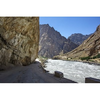

Pamir Highway is a unique sight of Tajikistan stretching for more than 1300km and connecting the capital of Dushanbe and the city of Osh in the south of Kyrgyzstan. The highway that is a part of an international road M41, lies via high-mountain region of Pamir. Pamir is a mountain range with peaks over 7000 meters that takes up most part of Tajikistan; its name is translated as “Roof of the world”.
There were once isolated mountain settlements and small states, but in the 19th century, the British and Russian empires began struggling for the influence in Asia known as “the Great Game”. During this confrontation, the English were moving to the north from India to Afghanistan, and the Russians were going from the north via the present territory of Kyrgyzstan and Tajikistan. The urgency to maneuver the troops quickly in case of clash of armies gave a jump to building new roads across mountain regions; this is how the Pamir Highway history get started.
Later, as Tajikistan was declared as a state within USSR, Pamir Highway changed its military significance to trade. The decision led to development of the region; transport connections between Tajikistan, Afghanistan and China were settled. Today Pamir tract begins in Dushanbe, the capital of Tajikistan, and goes through Kulab, reaches the river Panj – a tributary of the Amy-Darya River, branches out in Khorog - the capital of Gorno-Badakhshan, and lies via high-mountain town of Murghab; reaches Osh, the largest city in the south of Kyrgyzstan. More info about the road on Pamir Highway…
For travelers Pamir Highway is a unique experience where they learn the culture of Pamir people, history of the region, and enjoy breathtaking landscapes of severe mountains. This is rather tough travel where travelers overcome hundreds of kilometers of bad roads, harsh mountain climate, and spartan accommodation. Nowadays the tourism infrastructure along the Pamir Highway is being developed; although simple, but rather comfortable hotels and guesthouses have appeared. However, it is to consider that the region is far from urban civilization and one will have to live the life of locals, though this is what keeps the entire interest to the Pamir Highway.
As mentioned above, Pamir Highway tour is not an easy trip. The road goes via the highest point of 4655 meters on the pass of Ak-Baytal, where acclimatization is needed. Conveniences such as internet, comfortable accommodation and good food will gradually disappear. Rocky dirt roads and 8-10-hour daily drives will take all your energy, but all this is worth the unique atmosphere of real adventure where you indulge into the picturesque world of mountains. Every year the number of tourists traveling to Pamir is increasing, and today you will hear different languages. Therefore, if people are traveling there from all over the world, there is definitely something to see. You can reveal the secret of this attraction only by traveling to Pamir Highway.


