
The second voyage of James Cook
The second voyage of James Cook, from 1772 to 1775, commissioned by the British government with advice from the Royal Society, was designed to circumnavigate the globe as far south as possible to finally determine whether there was any great southern landmass, or Terra Australis. On his first voyage, Cook had demonstrated by circumnavigating New Zealand that it was not attached to a larger landmass to the south, and he charted almost the entire eastern coastline of Australia, yet Terra Australis was believed to lie further south. Alexander Dalrymple and others of the Royal Society still believed that this massive southern continent should exist. After a delay brought about by the botanist Joseph Banks' unreasonable demands, the ships Resolution and Adventure were fitted for the voyage and set sail for the Antarctic in July 1772.
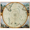
On 17 January 1773, Resolution was the first ship to venture south of the Antarctic Circle, which she did twice more on this voyage. The final such crossing, on 3 February 1774, was to be the most southerly penetration, reaching latitude 71°10′ South at longitude 106°54′ West. Cook undertook a series of vast sweeps across the Pacific, finally proving there was no Terra Australis in temperate latitudes by sailing over most of its predicted locations.
In the course of the voyage he visited Easter Island, the Marquesas, Tahiti, the Society Islands, Niue, the Tonga Islands, the New Hebrides, New Caledonia, Norfolk Island, Palmerston Island, South Sandwich Islands, and South Georgia, many of which he named in the process. Cook proved the Terra Australis Incognita to be a myth and predicted that an Antarctic land would be found beyond the ice barrier.
On this voyage the Larcum Kendall K1 chronometer was successfully employed by William Wales to calculate longitude. Wales compiled a log book of the voyage, recording locations and conditions, the use and testing of various instruments, as well as making many observations of the people and places encountered on the voyage.
Conception
In 1752, a member of the Royal Society of London, Alexander Dalrymple, had found Luis Váez de Torres' testimony proving the existence of a passage south of New Guinea now known as Torres Strait, whilst translating some Spanish documents captured in the Philippines. This discovery led Dalrymple to publish An Historical Collection of the Several Voyages and Discoveries in the South Pacific Ocean in 1770–1771 which aroused widespread interest in his claim of the existence of an unknown continent. Soon after his return from his first voyage in 1771, Commander Cook was commissioned by the Royal Society to make a second voyage in search of the supposed southern continent, Terra Australis Incognita.
Preparation and personnel
Portrait of James Cook by William Hodges, who accompanied Cook on his second voyage
Vessels and provisions Cook commanded HMS Resolution on this voyage, while Tobias Furneaux commanded its companion ship, HMS Adventure. Resolution began her career as the 462 ton North Sea collier Marquis of Granby, launched at Whitby in 1770, purchased by the Royal Navy in 1771 for £4,151, and converted to naval specifications for a cost of £6,565. She was 111 feet (34 m) long and 35 feet (11 m) abeam. She was originally registered as HMS Drake, but fearing this would upset the Spanish, she was renamed Resolution, on 25 December 1771. She was fitted out at Deptford with the most advanced navigational aids of the day, including an azimuth compass made by Henry Gregory, ice anchors and the latest apparatus for distilling fresh water from sea water. Twelve light 6-pounder guns and twelve swivel guns were carried. At his own expense Cook had brass door-hinges installed in the great cabin.
HMS Adventure began her career as the 340 ton North Sea collier Marquis of Rockingham, launched at Whitby in 1771. She was purchased by the Navy that year for £2,103 and named Rayleigh, then renamed Adventure. She was 97 feet (30 m) long, 28 feet (8.5 m) abeam and her draft was 13 feet (4.0 m) and carried ten guns. Both were built at the Fishburn yard at Whitby and purchased from Captain William Hammond of Hull. Cook was asked to test the Larcum Kendall K1 chronometer on this voyage. The Board of Longitude had asked Kendall to copy and develop John Harrison's fourth model of a clock (H4) useful for navigation at sea. The first model finished by Kendall in 1769 was an accurate copy of H4, cost £450, and is known today as K1. Although constructed like a watch, the chronometer had a diameter of 13 cm and weighed 1.45 kg. Three other clocks, constructed by John Arnold were carried but did not withstand the rigors of the journey. The performance of the clocks was recorded in the logbooks of astronomers William Wales and William Bayly and as early as 1772 Wales had noted that the watch by Kendall was 'infinitely more to be depended on.


